 |
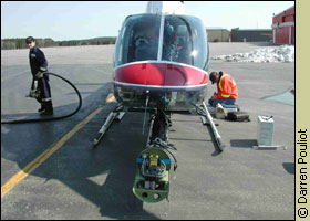
| Multispectral digital camera mounted
on helicopter boom would take aerial photos. |
When Ottawa
forestry researcher Darren Pouliot saw people walking around in
shorts last April he started to worry.
After listening to the long-range weather forecast,
he threw some equipment into a rented jeep and began a 21-hour
marathon drive to the boreal forest near Sioux Lookout, four hours
from Thunder Bay in northwestern Ontario.
Pouliot, 28, needed to collect data for his PhD research and
it depended on a narrow window of time between snowmelt and new
spring growth.
If he missed the window, his work would be delayed by a full
year.
Driving straight through, with his research assistant Mark Lindsay
spelling him off at the wheel, Pouliot made a pit stop in Thunder
Bay to pick up a $24,000 camera, on loan to his supervisor, Dr.
Doug King, in Carleton University's department of geography and
environmental studies.
No point-and-shoot camera, this multispectral digital wonder
would allow Pouliot to use the science of remote sensing —
gathering data about the Earth from the air — to take high
resolution photographs of the forest during flight.
Remote sensing uses a camera's sensor to measure energy reflected
from the ground. Ground features reflect electromagnetic energy
differently depending on surface roughness, moisture and light-absorbing
pigments.
The degree of detail depends on the distance between the target
and the sensor.
An astronaut, for example, would see the entire boreal forest
in one glance, but would not be able to distinguish individual
trees.
Scanning the forest
| 'Remote sensing is particularly useful in remote, inaccessible
areas of the vast boreal forest' |
Remote sensing is not new to foresters. The Canada Centre for
Remote Sensing has used the surveillance tool for 30 years to
do reconnaissance mapping, monitor forest fires and to keep an
eye on the rate and extent of deforestation.
Doug Pitt, a research scientist with the Canadian Forest Service
says aerial photography, with manual interpretation of the images,
has traditionally been used.
However, as more sophisticated digital cameras have become available,
researchers like Pouliot are looking to improve accuracy and speed
up the analysis of aerial photographs through computer automation.
Remote sensing is particularly useful in remote, inaccessible
areas of the vast boreal forest.
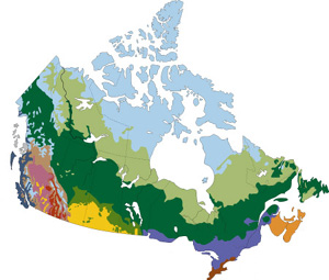
The green belt of the boreal forest stretches from coast to
coast, covering 35 per cent of Canadas landmass.
| An astronaut would see the entire boreal forest in one glance,
but would not be able to distinguish individual trees. |
It contains a mix of coniferous trees (softwood, with needles)
and deciduous trees (hardwood, with leaves) but Pouliot was specifically
interested in the young conifer trees regenerating on a patch
of Crown land clear-cut nine years ago.
In the early spring, when deciduous trees such as birch and aspen
are still in a dormant, leafless state, the conifers foliage
would appear starkly green from the air, against the drab backdrop
of brown forest floor.
With the specialized camera, Pouliot planned to fly over the
forest and acquire colour images in the green, red and near infrared
wavelengths of the spectrum.
A bird's-eye-view
Viewed directly above, tree crowns look like amoeba-shaped blobs.
Since the conifers green needles reflect large amounts of energy
in the near infrared, the blobs would appear bright pink in the
photo, against a blue-green background.
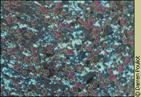 |
| Conifer tree crowns absorb light in
the infrared and show up as pink blobs. |
A birds-eye-view of conifer crowns is not only useful to count
the number of trees in the image, but it also reveals important
information about the tree species, height, volume and biomass.
By measuring crown diameters, a logging company can calculate
how much wood volume will feed hungry mills.
Foresters and climatologists also use crown diameters to calculate
how much carbon is stored in tree trunks. Trees act as an
important global sink, sequestering carbon from carbon dioxide
— a primary greenhouse gas — while releasing oxygen
to the air.
| A birds-eye-view of conifer crowns is not
only useful to count the number of trees in the image, but
it also reveals important information about the tree species,
height, volume and biomass. |
Close inspection of the tree crown image can also reveal the
trees health, or whether insects have damaged the foliage.
But Pouliot wanted to use tree crown data for a relatively new
forestry application: to determine how well conifers regenerate
after clear-cutting.
When a tree falls in the forest
While clear-cutting can cause soil erosion and destroy habitat
for wildlife, it is actually an appropriate harvesting practice
in the boreal forest because it mimics the large-scale disturbances
of natural forest fires.
The key to long-term sustainability of forests depends on successful
regeneration.
Natural regeneration occurs when young trees grow back from roots
and seeds. Forests can also be artificially regenerated by sowing
seeds or planting nursery-grown seedlings.
More than 50 per cent of clear-cut boreal forest is left to
regenerate on its own. This can create problems.
Sun-loving deciduous trees such as birch and aspen can outpace
slower-growing conifers on clear-cut sites, competing for sunlight,
water and soil nutrients.
Unchecked, they may choke out the conifers and eventually replace
native conifer stands with hardwood.
To maintain cutting quotas, logging companies must prove to
forest conservation managers that conifers are regenerating, by
doing a free-to-grow assessment, 7-10 years after clearcutting.
"Teenaged" trees
At 7 - 10 years of age, conifers are a bit like teenagers getting
ready to leave home for the first time — finally tall and
mature enough to merit what the ministry of natural resources
calls free-to-grow status.
| At 7-10 years of age, conifers are a bit like teenagers
getting ready to leave home for the first time — finally
tall and mature enough to merit what the ministry of natural
resources calls free-to-grow status. |
At this point, the young conifers are likely to reach maturity,
unhindered by competing species. To help conifers reach this crucial
stage of development, intervention may be required, such as soil
fertilization, or clearing away competing vegetation by manual
cutting or chemical herbicides.
The traditional way to check up on regeneration is to tramp through
the forest or take a look from an aircraft window, which can be
very subjective.
Pouliots research goal is to develop an algorithm, or an automated
computer program that will replace the subjective assessments
of forest regeneration with more objective, cost-effective and
accurate assessments.
After their marathon drive, Pouliot and Lindsay parked the jeep
outside a small trailer in the bush, on loan from Buchanan Forest
Products, a private logging company that leases a tract of Crown
land one hour from Sioux Lookout.
Plunging temperatures
Before rigging the camera up, Pouliot had plenty of work to do
on the ground. But he wouldnt be wearing shorts.
After rushing north to beat the heat wave, the temperature plunged.
It was miserably cold for three weeks, he says.
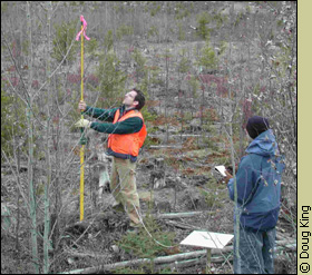 |
| Darren Pouliot and Mark Lindsay take
measurements in a research plot near Sioux Lookout. |
With hands growing painfully numb clasping pen and notepad, the
two researchers first staked out a series of research plots, then
took careful measurements of each individual tree.
Crown diameter, trunk diameter, tree height and total above-ground
biomass were all jotted down in neat rows of figures.
Measuring the same trees from the air came next.
Chopper challenge
King arrived from Ottawa to help mount the camcorder-sized camera
to the boom of a helicopter.
| With hands growing painfully numb clasping pen and notepad,
the two researchers first staked out a series of research
plots, then took careful measurements of each individual tree. |
It took about four days to feed cables to a computer inside
the cockpit and to check all the software.
King pioneered multispectral airborne video sensing in the 1980s
when he rigged up four cameras to a VCR unit to digitize photographs
in the days before digital cameras were available.
His expertise was invaluable, because once the helicopter lifted
off the tarmac, the flight recorder would be billing, even at
a reduced academic rate, $1,300 an hour.
When all systems checked out during a test flight, King returned
to Ottawa and Pouliot went back to the forest to spend a few more
days taking meticulous ground measurements.
He was finally ready to collect the data that would keep him
busy for the next two years of analysis.
Then Mother Nature did what she often does at northern latitudes
in April: the day before the helicopter charter, 15 cm of snow
fell on Pouliots conifer trees. Twenty four hours later, the
temperature soared to 22 C.
 |
| The day before the aerial flight, 15
cm of fresh snow fell on the research plot. |
We were running around to various locations in the bush, measuring
snow depth, Pouliot recalls.
But he was also keeping a wary eye on the deciduous trees, which
were just ready to burst into green leaf and invalidate his data.
He decided he couldnt afford to wait another day.
Weather finally cooperates
Fortunately mission day dawned sunny and clear, with bright sun
to illuminate the green conifers.
Flying at approximately 200 metres, Pouliot spent eight hours
snapping high-resolution digital photos over the research plots.
Pixel by pixel, the images were fed into the computer.
| 'We were running around to various locations in the bush,
measuring snow depth' |
At this elevation, each pixel — the smallest element of
a picture — corresponded to a 36 square centimetre area
on the ground. This would be more than enough detail to detect
individual conifer tree crowns.
Back on the ground, with the images safely burned onto CDs and
archived, Pouliot made a preliminary check to compare the images
with was was growing on the ground.
They looked good.
And plentiful enough to keep Pouliot busy for at least two years
of analysis and testing to develop an automated computer program
that will assess forest regeneration more accurately and more
economically than current methods.
When every last field measurement was recorded and double-checked,
Pouliot and Lindsay packed up their gear and headed back to Ottawa.
They had a lot of dirty laundry.
But they no longer had to worry about changes in the weather.
And mercifully, they had just missed the boreal black flies.
|