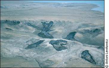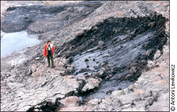
From the air, enormous dark amoebas stretch across the landscape of low hills and valleys of the Fosheim Peninsula on Ellesmere Island in the High Eastern Arctic. The dark splotches are scars from landslides. Within a period of 10 days in late July 1988, hundreds of landslides carried tonnes of soil into three creek valleys on the Fosheim Peninsula. Some of the slides were 600 metres long and 100 metres wide, about the size of three football fields. Permafrost researcher, Antoni Lewkowicz, flew to northern Ellesmere Island to find out what had caused them. Lewkowicz, a professor at University of Ottawas geography department, determined that a brief period of warm weather had quickly thawed the active layer, causing it to slide off the permafrost. The active layer is the top section of soil that freezes every autumn and thaws every spring. Beneath the active layer is permafrost, the soil or rock that remains below 0 C year round. Permafrost underlies the northern half of Canada. It ranges from several metres thick in the southern Northwest Territories to 700 metres thick in the High Arctic. The active layer is the biggest indicator of how permafrost reacts to air temperature, so is considered a possible gauge of climate change on permafrost. Lewkowicz explains how the landslides happen. As water in the soil is sucked towards the freezing fronts, ice lenses form at both the top and bottom of the active layer. When the active layer thaws the following summer, the soil near the surface becomes gloopy and has very little strength. If it thaws slowly, the water from the ice lenses drain away, the layer dries out and there is no problem. But if it thaws quickly, the water cant drain fast enough and the bottom of the active layer becomes gloopy like the top.
Ice is a slippery surface. Even on a slight incline a person can slide. It is the same with earth on permafrost. Without friction between the thawed and frozen permafrost zones, the soil slides off. In 1998 after another brief warm period, over 40 more active layer detachment slides occurred in the Fosheim Peninsula. Lewkowicz then measured the new slides to see if there was any correlation to the ones in 1988. His results were inconclusive. Though the series of slides occurred 10 years apart, detachment slides are not unusual in the Fosheim region. It has been happening in these areas for probably the last 10,000
years, but is it happening more frequently now? That is the big issue
that we dont fully understand, Lewkowicz says. Permafrost has been studied in Canadas North since the 1940s. But Lewkowicz says it needs to be monitored for longer periods of time to determine if the 1988 and 1998 slides are part of a pattern or just chance. Because they only require a single warm summer or period of warmth in a particular summer, you cant really say theyre directly related to an overall warming trend. In fact, there isnt one, Lewkowicz says. Though the active layer will get thicker with changes in air temperature, the continuous permafrost is so dense it wont immediately reflect surface changes. On Ellesmere Island the permafrost is 700 metres thick, and with a temperature of 17C even if it increases by three or four degrees, it will only warm up to 13 C or 14 C, which will have little impact on the surface environment. Lewkowicz says this will take decades to centuries to happen. The Geological Survey of Canada Permafrost and Climate Change Web site echoes Lewkowicz stating, There is generally a lag between a change in temperature at the ground surface and the change in permafrost at depth; for thick permafrost this lag may be on the order of hundreds to thousands of years, for thin permafrost, years to decades. The Geological Survey maintains a national permafrost database, containing information from all over Canada. Much of the information is compiled from five northern borehole sites with temperature cables in them. These monitor permafrost temperature changes over time. Sharon Smith, a permafrost researcher at the Geological Survey, says, as you get deeper in the ground, the short-term daily temperature variations are naturally filtered out and the seasonal longer-term trends are more visible. So the deeper holes offer a historical view of the changes at the surface over time.
1998 was touted as the warmest year on record, but that wasnt the case everywhere in Canada. The country has such a large permafrost area that it is virtually impossible to generalize over the whole region, Smith says. Just because you increase the air temperature doesnt mean youll see the same proportional increase in the ground temperature. You have to look at snow cover, moisture content in the ground and other factors, Smith says. In the mid-western Arctic, large regions of the permafrost are discontinuous, which means there are areas where the ground is not permanently frozen. The permafrost here is not as thick as in the High Arctic either. It is also being closely monitored to determine if warming temperatures are affecting it. In the Western Arctic it appears that permafrost is 1 C to 1.5 C warmer than it was in the late 60s and early 70s, says Chris Burn, a permafrost expert and professor at the Department of Geography at Carleton University. Burn has been studying permafrost in the Mackenzie Valley and Central Yukon for over 20 years. The data he collects is used by industries involved in mining, and construction of pipelines, roads and buildings in the North. Burn says there was consistent warming of the ground in the 70s and
80s in the Central Yukon. If it had continued into the 90s it wouldve
resulted in a thawing of the near surface of permafrost, but a series
of years in the early 90s with very little snow cover resulted in the
ground being as cold as it was before the warming. These variables make
it difficult to create models to determine the affects of climate change
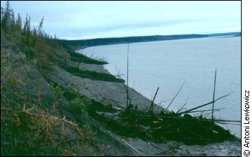
on permafrost. Im not all gloom and doom. I dont think the end of the world is coming with climate change, Burn says. But I do think there are serious issues with climate change related to hill slope stability. Because if the ice beneath the surface of the hill slope melts then the hillside loses its stability and you can have a landslide. The Geological Survey Web site says 2,000 landslides have been mapped in the Mackenzie Valley from aerial photographs. Slides in the valley are of particular concern because of the potential damage to the river ecology by silt from the collapsed hillsides.
Burn says the most frequent disturbance of ground conditions is not climate but forest fire. Fire destroys the vegetation and groundcover, which is what prevents the ground from melting beneath it. Also without branches, the snow falls directly on the ground and acts as insulation, so the ground gets warmer. Anywhere that there is a hillside, youll see landslides after forest fires because the permafrost has melted, Burn says.
The loss of vegetation and extra snow means the permafrost thaws faster and deeper after a forest fire, but curiously not as a result of the actual heat from the fire. Larry Dyke, at the Geological Survey, specializes in permafrost and slope stability along the Mackenzie River. He says 1998 was 3.9 C degrees warmer than the mean annual temperature since 1948. The following summer he went up the Mackenzie River to study landslides but only found two places where there had been slides that spring as a result of the warmer weather the year before. The only other places he saw slides were in areas where there had been forest fires. He says that there would need to be an extremely warm summer with temperatures of 10 C to 15 C above normal before there would be noticeable effects of permafrost thaw. He agrees with Burn that it is forest fire that causes the majority of landslides. If climate change resulted in more forest fires, then I think youd see more sliding, Dyke says. Forest fires are an anticipated consequence of climate change. If things get warmer, conditions get drier and there may be more convective lightning storms. Lightening starts 90 per cent of forest fires, so they are difficult to prevent. Though landslides related to melting permafrost have been triggered by fire, researchers have not found that warming of the air significantly affects permafrost. Theres no question the climate has warmed over the century, Dyke says. But permafrost is pretty resistant to climate change.
|
|