|
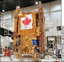
The 50-foot long, 2,000 pound radar and mammoth-size bus (the main body) will soon be joined to form Radarsat 2, Canada’s latest cutting-edge satellite technology. Various parts have arrived at the Canadian Space Agency’s testing location in the past seven months, but CSA and partner MDA Ltd. originally planned to build the satellite five years ago. Now slated for a Russian launch at the end of 2006, Radarsat 2 was supposed to be launched by the United States in 2003. When they learned how powerful the new satellite would be, they backed out. The ability to identify a car driving down a highway from orbit made U.S. authorities nervous, says Jean-Guy Dumoulin, an engineer with CSA. “They say, wow, they can see George Bush sitting in the back yard having his beer,” says Dumoulin. “So they didn’t like it.” The clock is ticking Delays mean that Radarsat 2 is needed now more than ever to replace its predecessor. Radarsat 1 was designed to stay in orbit for five years, and has now more than doubled that lifespan. Despite plans to launch the satellite in December, there is still a lot that could go wrong to further delay Radarsat 2. Between different stages of assembly the satellite goes through a grueling set of tests. The radar is signal-tested on a wide range of frequencies, and the body is put through extreme hot and cold temperatures. To top it all off, the whole satellite is shaken vigorously. All testing is done to ensure Canada’s leading satellite technology stands up to the harsh environment of outer space. A picture is worth... Aside from who will launch Radarsat 2, delays were caused by difficulties in crafting the world’s best earth-imaging satellite technology. “The main delay was caused by the technology just needing more time to be developed,” Dumoulin says. Planned to last until 2012, scientists need to think ahead so Radarsat 2 won’t be obsolete too soon after launch. CSA spent $400 million to produce the highest resolution images to be captured from a satellite, at half the cost of Radarsat 1. The technology is called synthetic aperture radar – meaning that as the satellite soars over earth, it combines reflected microwave signals to build an image. The device will take images of the earth as close as three meters in resolution. That means it could see different cars on a road, or even individual trees in a forest. The microwaves the satellite sends out can penetrate weather such as clouds and rain. Both horizontal and vertically oriented waves are sent out by the radar, and the scattering patterns of the waves create the image. A crop of corn for example, would scatter vertical waves while allowing horizontal waves to pass through to the ground. MDA Ltd. is developing the satellite in cooperation with CSA. The private company will be allowed to sell images commercially, while the CSA gets free access to the pictures. Before they start collecting images, the team has to make sure their ship will fly. Another use for packing foam
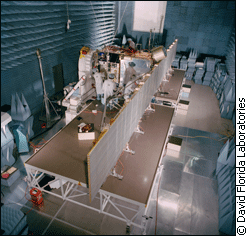
The imaging technology of the satellite relies on being able to receive microwave signals on a wide range of frequencies. Engineers also communicate with and program the satellite using the same method. Tests in the radio-frequency facility at the laboratory ensure the satellite will take clean images and scientists will be able to download them. The test room is cavernous and dark, and the walls are covered with packing-foam pyramids of various sizes. About $400,000 of carbon-molecule-packed foam material lining the room simulates an outer space environment, says Dumoulin, the room’s designer. “A flat surface will always have some reflected bounce from it, but if that surface is slightly angled, then the reflected signal is less,” he explains. “You don’t want the reflected signal because in space the craft doesn’t see it.” The large-size foam pyramids absorb lower-frequency wavelengths with higher amplitude, while smaller foam pyramids soak up the high-frequency, low-amplitude wavelengths. The carbon molecules in each pyramid help absorb the radio waves, vibrating to convert their energy into heat instead. The result is a room that absorbs radio signal strengths ranging from that of your home shortwave radio up to a commercial radio tower. After the radar passes the test, it will be attached to the main body of the satellite. The physical connection is simple – there are three bolts that fasten the radar to the spacecraft on either side, says Alex Golob, assembly, integration and technology manager for MDA Inc. He hopes to put the pieces together in May. Shake and bake When that is done, the satellite can be placed in a chamber devoid of air and exposed to temperatures between -150 and +150 C. In space, the satellite will need to operate in an air-free environment and will be exposed to extreme temperatures. Hot when it faces the sun, and cold when it is facing away.
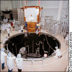
“It is like camping, when you have the fire going at night and you have your front facing the fire, your front gets hot and your back is cold,” Dumoulin says. The chamber is over 10m deep and wide enough to drive a truck into, so larger satellites like Radarsat 2 can fit. Heat lamps are used to bring the temperature up to the maximum. To bring the temperature down 150 degrees below freezing, liquid nitrogen flows through ridges along the black walls of the chamber. “You wouldn’t survive more than a few seconds in this chamber,” Dumoulin says. But the satellite has to. Every mechanical component on the spacecraft must withstand the stress of the extreme temperatures.
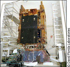
After the satellite sits in the vacuum chamber for two to three weeks, the next phase is vibration testing, which lasts only a few minutes. The scientists at the laboratories call the combination the “shake and bake” tests, Dumoulin says. “You want to simulate what happens during launch,” he says. “Depending on the launcher, you want to represent the same vibration spectrum here.” The satellite’s ride up to its 800 km high orbit is a bumpy one. Scientists need to make sure it will hold together before strapping it to a rocket. Radarsat 2 sits atop a large transducer to give it a shake-up. Much like the loudspeakers of your home stereo system, a combination of frequency signal and power supply make this transducer jolt up and down. The difference is this transducer is about 25,000 times more powerful than your speakers. Using data supplied from the Russians, scientists will simulate the launch rocket by feeding the transducer the same frequency of vibrations. Though the minimum vibration levels of the launcher must be met in the test, it will likely be even more rigorous. The transducer can also be rotated 90 degrees to a horizontal orientation. It then shakes a large table connected to it. Meanwhile devices on Radarsat 2 will measure the forces experienced. “You’ll spend two weeks, three weeks, getting ready for a test, and then it is over in a few minutes,” Dumoulin says. Say 'cheese' After its final testing, Radarsat 2 will be shipped to Russia. A flatbed truck with a depression in the middle of the cargo space is used to get the spacecraft to the airport, Dumoulin says, and it is flown from there. Once Radarsat 2 is launched CSA and MDA Inc. will see if their testing pays off. The first hurdle to jump after attaining orbit is deploying the radar. Folded away to fit into the rocket ferry, the extended support structure fans out to start the radar. “If it doesn’t deploy the wings, it is pretty much a write-off,” Golob says. He has conducted over 20 tests of the deployment mechanism with weights in place of the radar. To simulate the zero-gravity space environment, the test is done on what Golob calls “a giant air-hockey table.” If successful, Radarsat 2 will provide the highest-resolution earth imaging pictures available. It will be able to track the thaw of arctic ice, do studies on vegetation, and be used for military tactics. There are currently no plans to use it to monitor the U.S. President's leisure habits in his backyard.
|
|
|