|
|
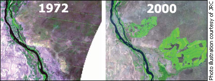
Scientists from the European Commission's Joint Research Centre used images taken from at least 700 kilometres above the Earth's surface to monitor the impacts of Africa's fast-growing population on the land that supports it. After comparing satellite pictures of sub-Saharan Africa in the 1970s and around the year 2000, the scientists say Earth-observing satellites provide crucial information on agriculture and natural resources that can be used as the basis of development initiatives. Two images taken of the Sudan along the Nile River are tell-tale of a trend the JRC's study revealed. There are a few lime-coloured specks in a photo from 1972. A picture of the same spot 28 years later shows large bright green portions of land that are under irrigation. According to the study, natural vegetation in this area was converted to agriculture at higher rates than anywhere else in sub-Saharan Africa.
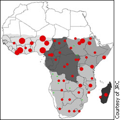
For an Earth-observing system to measure vegetation, energy from the sun shoots down onto vegetation on the planet's surface. Some of that energy is absorbed, but what isn't used — for photosynthesis for example — is bounced back through the atmosphere and captured by a remote sensing system mounted to a satellite. How much energy is absorbed, reflected and measured by a system depends on the vegetation type, season and general conditions, says Hugh Eva, a physicist and co-author of a report based on the JRC study of Africa. "If you look at the vegetation and it's changed how it has absorbed [energy], then it's changed," Eva says. Converting natural vegetation to veggies In sub-Saharan Africa, where at least 1.23-million square kilometres of natural vegetation has been converted to crops since the mid-1970s, Earth-observing satellites see transformations occurring because the way the Earth's surface absorbs and reflects energy also changes. Although converting land to crops is one way of increasing food production to support the nearly 900 million people living in Africa – a figure that was at 408 million in 1975 – Alan Belward, a JRC plant biologist, warns this will lead to long-term food insecurity.
“A lot of the agricultural conversion has been based on land clearance and land-use conversion, not production intensification,” Belward says, “and that paradigm is going to have to change because [in some countries] there is no land left.” Belward says smaller-scale studies similar to the one the JRC conducted are necessary for individual regions to get a stronger understanding of their land and to use this information for making decisions about food production and natural resources. Alex Atim, a Ugandan studying geographic information science at Clark University in Worcester, Massachusetts is attempting to conduct one such study. He’s looking at violence caused by natural resource shortages around protected areas in his country. Earth-observing satellites pick up conflict-triggering acts such as poaching and illegal logging just by having sediments stirred up in aeras that aren't supposed to be used for these activities. Remote sensing systems measure a change in electromagnetic radiation reflected off the land and this subtle change in the environment suggests people may be engaging in illegal activities. These are the types of things Atim would be looking for if he could get a good look at Uganda. “It’s very difficult to get good satellite images for Africa,” he says. “Most of them are very low resolution and the cloud cover is so enormous you can’t use it.” This is a challenge JRC researchers also faced, particularly with data from the 1970s. Low-resolution images and clouds made some data unusable and they had to work around this by looking at images from as close to their target year – 1975 – as possible. Young scientists like Atim are part of a solution to another challenge in converting Earth observation into a fully-functional tool for delivering information to Africa. Belward says there needs to be more scientists in Africa capable of interpreting satellite imagery and providing information to their own network of decision makers. He says equipping sub-Saharan African nations with Earth observing capabilities can lead to improved food security and conflict resolution. “The view from space is one neutral and sharable and transparent source of information,” he says, “… we want this technology to move into these countries and stay in these countries.”
|
|
|